 GeoProfile
Summary
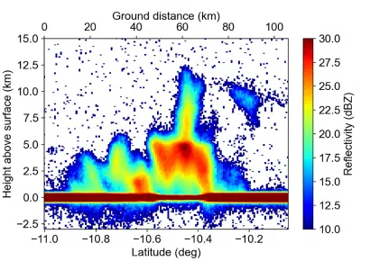
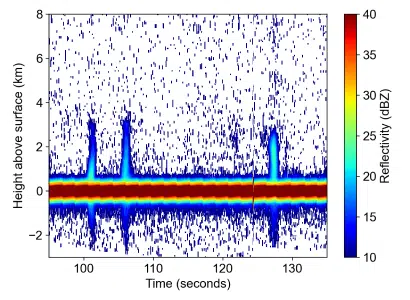
The fundamental measurement collected by the satellite is reflectivity as a function of radar range. Reflectivity is a measure of the backscatter from volumes of precipitation in the atmosphere, and “radar range” means distance from the radar. From this data, reflectivity as a function of height above Earth’s surface can be derived. An example plot of this data is shown below. In the plot, the reflections in the atmosphere (above the surface) are precipitation, and the strong reflectivity seen at the Earth’s surface is backscatter from the surface itself. The surface backscatter has an extended effect in range, often referred to as “surface clutter”, which exists both above and below the true surface of the Earth.
Level 1C data, aka L1C-GEOPROF, is geolocated, calibrated radar reflectivity profiles at the native sampling resolution. Given the capabilities and conops of Tomorrow-R1 and Tomorrow-R2, each radar scan is a two dimensional slice of the atmosphere.
Product Information
The L1C data is contained in a netCDF file. Each file consists of a sequential series of observations that define a “measurement granule,” and each granule consists of a discrete number of time steps. Each file does not necessarily correspond to a single radar scan, but instead, each file is a portion of a radar scan with identical sampling parameters throughout the file.
The L1C data initially available is a sample of data collected for evaluation purposes. The radar scans provided include different types of weather conditions. The satellites are still undergoing overall calibration and validation, and once the initial cal/val is complete, larger and regularly-updated datasets will be available.
![]() tmrw-l1c-cal-reflectivity-samples.zip
tmrw-l1c-cal-reflectivity-samples.zip